Two Oceans Marathon 2027 weather: what race day will likely feel like
The short answer
Race day at the Two Oceans Ultra Marathon (Sunday 4 April 2027) is usually mild, humid and breezy: about 16° at the 06:00 start and 19° at a six-and-a-quarter-hour finish, with a south-easterly wind. In 10 years of records the heat stress was Moderate or more on most days, and the run from Fish Hoek over Chapman's Peak was the windiest stretch.
The 2027 Totalsports Two Oceans Ultra Marathon is on Sunday 4 April: 56 km round the Cape Peninsula, from Newlands down Main Road to Muizenberg and Fish Hoek, over Chapman's Peak to Hout Bay, and back over Constantia Nek to the finish at UCT. Here's what race day has usually felt like, section by section, for a runner in the middle of the field.
What will the weather be like at the 2027 Two Oceans Marathon?
Usually mild, humid and breezy: a pleasant start, then a warm, sticky last 15 km. In the records, a runner from the 06:00 start set off at about 16° and finished at about 19°, with a dew point near 14°. RunFast's engine rated race day Good on 1 day in 10, Fair on 8 and Tough on 1.
The heat stress (WBGT, the number race medical teams use) was usually about 20°. It reached Moderate or more on about 8 days in 10, and High on about 1. The warmest race day in the records reached 24°.
| Section | Where | Air | Heat stress | Wind | Rated, days in 10 |
|---|---|---|---|---|---|
| 1 · 06:00km 0–12 | Main Road: Newlands to Lakeside | 16°dew point 14° | LowModerate or more 0 in 10 | 16 km/hfrom the south-east | |
| 2 · 07:15km 12–19 | False Bay: Muizenberg to Fish Hoek | 16°dew point 14° | LowModerate or more 0 in 10 | 16 km/hfrom the south-east | |
| 3 · 08:05km 19–28 | Kommetjie Road and Noordhoek | 17°dew point 14° | LowModerate or more 2 in 10 | 22 km/hfrom the south-east | |
| 4 · 09:07km 28–39 | Chapman's Peak Drive | 16°dew point 14° | LowModerate or more 3 in 10 | 22 km/hfrom the south-east | |
| 5 · 10:22km 39–42.2 | Hout Bay to Constantia Nek | 17°dew point 14° | ModerateModerate or more 7 in 10 | 20 km/hfrom the south-east | |
| 6 · 11:12km 46–42.2 | Rhodes Drive to Kirstenbosch | 19°dew point 14° | ModerateModerate or more 8 in 10 | 17 km/hfrom the south | |
| 7 · 11:50km 52–42.2 | Kirstenbosch to UCT | 19°dew point 14° | ModerateModerate or more 8 in 10 | 17 km/hfrom the south |
Where does the weather usually cost runners time?
The heat and the wind, about equally. On the middle day of the records, the weather cost a 6:42-per-km runner about 11 minutes over the whole race, and 15 minutes or more on 1 day in 10. The heat was the main cause on about 5 of those days in 10.
 Start · NewlandsMuizenbergFish HoekChapman's PeakHout BayFinish · UCT1234567Historic
- Ideal
- A little slower
- Hard
- Very hard
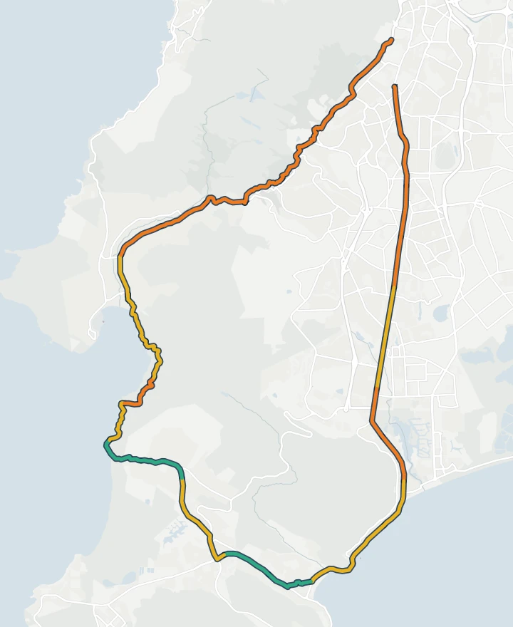
Each stretch is coloured by how hard the weather made it at 6:42 per km, at the hour a runner from the 06:00 start gets there, on the middle day of the records around 4 April, 2015 to 2024 (Historic). The numbers are the seven sections below.
Weather: contains modified Copernicus Climate Change Service information (ERA5). Course line: drawn along the roads of the organiser's route map, from © OpenStreetMap contributors. Map: OpenFreeMap, © OpenMapTiles, © OpenStreetMap contributors.
Orange for the first 15 km, down Main Road and along False Bay, where the south-easter is in runners' faces: on a middle day each stretch is about 3 to 3.5% slower. Mostly green from Kommetjie Road over Chapman's Peak, with the wind usually behind. Then orange again for the last 15 km, from Hout Bay up to Constantia Nek and down to the finish, about 4 to 6% slower, as the morning warms and the air stays humid. The wind usually comes from the south-east at 16 to 22 km/h. The course turns through almost every direction as it goes round the peninsula, so it's in runners' faces down Main Road and along False Bay to Fish Hoek, behind them on Kommetjie Road and over Chapman's Peak, and more often behind than against on the run in from Constantia Nek to UCT.
What is each section likely to feel like?
Each section with its usual race morning, hour by hour, timed for the 06:00 start and a steady 6:42 per km.
1. Main Road: Newlands to Lakeside
The first 12 km run south down Main Road from the start at Newlands, through Claremont, Wynberg, Diep River and Bergvliet to Lakeside, on the organiser's route map. It starts in the dark: it was about 16° at the start, with the south-easter, about 16 km/h, mostly in runners' faces on about 5 days in 10.
- Heat stress
- WBGT 15°Rarely Moderate
- Air
- 16°15–17° on 8 days in 10
- Dew point
- 14°16° or more on 1 day in 10
- Wind
- 16 km/h from the south-eastMostly a headwind on 5 days in 10
- Weather toll
- 2.4 min5.9 min or more on 1 day in 10
The usual hour here on race morning: air and dew point °C, heat stress (WBGT, coloured Low, Moderate, High or Extreme), wind km/h, and the share of hours with rain. The hours a 6:42 per km runner is here are marked.
2. False Bay: Muizenberg to Fish Hoek
Along the False Bay coast on Main Road, through Muizenberg, St James and Kalk Bay to Fish Hoek at 19 km. It's about 16° as the sun comes up, and the wind was still in runners' faces, mostly a headwind on about 6 days in 10.
- Heat stress
- WBGT 15°Rarely Moderate
- Air
- 16°15–17° on 8 days in 10
- Dew point
- 14°16° or more on 1 day in 10
- Wind
- 16 km/h from the south-eastMostly a headwind on 6 days in 10
- Weather toll
- 1.4 min3.4 min or more on 1 day in 10
3. Kommetjie Road and Noordhoek
Across the peninsula from Fish Hoek on Kommetjie Road, then Noordhoek Main Road to Noordhoek Common at 28 km, where there's a food station at 25 km. Across the peninsula the course turns, and the south-easter, now about 22 km/h, is mostly behind runners, on about 6 days in 10. It's about 17° and humid, with a dew point near 14°, and the heat stress reached Moderate on about 2 days in 10. This section was rated Good on about 5 days in 10, the most of any.
- Heat stress
- WBGT 17°Moderate or more on 2 days in 10
- Air
- 17°16–18° on 8 days in 10
- Dew point
- 14°16° or more on 1 day in 10
- Wind
- 22 km/h from the south-eastMostly a headwind on 3 days in 10
- Weather toll
- 0.6 min3.7 min or more on 1 day in 10
4. Chapman's Peak Drive
The climb that makes the race: Chapman's Peak Drive from Little Chappies at 30 km, rising on the organiser's elevation profile to its high point around 33 km, then down to Hout Bay at 39 km. The wind, about 22 km/h from the south-east, was mostly behind runners on about 6 days in 10 and in their faces on about 3, and this section was rated Good on 5 days in 10 and Tough on 2. The records can't see the cliffs' own shelter or gusts.
- Heat stress
- WBGT 17°Moderate or more on 3 days in 10
- Air
- 16°14–17° on 8 days in 10
- Dew point
- 14°16° or more on 1 day in 10
- Wind
- 22 km/h from the south-eastMostly a headwind on 3 days in 10
- Weather toll
- 1.3 min5.1 min or more on 1 day in 10
5. Hout Bay to Constantia Nek
Through Hout Bay on Main Road, then the long climb to Constantia Nek at 46 km, the highest point on the organiser's elevation profile. It's the warmer part of the morning by now: about 17°, and the heat stress reached Moderate on about 7 days in 10.
- Heat stress
- WBGT 20°Moderate or more on 7 days in 10
- Air
- 17°16–19° on 8 days in 10
- Dew point
- 14°16° or more on 1 day in 10
- Wind
- 20 km/h from the south-eastMostly a headwind on 1 day in 10
- Weather toll
- 2.3 min3.2 min or more on 1 day in 10
6. Rhodes Drive to Kirstenbosch
Down from the Nek on Rhodes Drive, under the trees, to the Kirstenbosch main gate at 52 km. Downhill under the trees, but it's about 19° and humid by now, and the heat stress reached Moderate on about 8 days in 10. This section was rated Tough on 5 days in 10.
- Heat stress
- WBGT 20°Moderate or more on 8 days in 10
- Air
- 19°17–21° on 8 days in 10
- Dew point
- 14°16° or more on 1 day in 10
- Wind
- 17 km/h from the southRarely a headwind
- Weather toll
- 1.8 min2.6 min or more on 1 day in 10
7. Kirstenbosch to UCT
The last 4 km, past the M3 Wildlife Services entrance at 54 km and up to the finish on the UCT Rugby Fields, Upper Campus. It's about 19° at a 6:15 finish, with a dew point near 14°, and the heat stress reached Moderate on about 8 days in 10. Like the stretch before it, the run in to UCT was rated Tough on 5 days in 10, the most of any section.
- Heat stress
- WBGT 20°Moderate or more on 8 days in 10
- Air
- 19°17–21° on 8 days in 10
- Dew point
- 14°16° or more on 1 day in 10
- Wind
- 17 km/h from the southRarely a headwind
- Weather toll
- 1.2 min1.8 min or more on 1 day in 10
What should runners wear and pack for race day?
Light kit for 16–19°, a layer for the wait, and the organiser's compulsory kit. The organiser's Ultra Marathon page has the start batches, the compulsory kit, the 19 hydration stations and the cut-offs. From the weather records:
- A throwaway layer for the start. Runners load into their batches well before 06:00, and it was about 16° during the wait, 14° or colder on 1 morning in 10.
- Race kit for 16–19°. It starts in the dark and finishes late morning.
- Something for Chapman's Peak. The south-easter, about 22 km/h there, was mostly behind runners on about 6 days in 10, but its gusts reach about 30 km/h.
- A cap and sunscreen on clear days. Heat stress reached Moderate or more on about 8 days in 10, mostly on the climb from Hout Bay to Constantia Nek and the run to the finish, after about 10:30. Check the organiser's guidance on the day.
The final cut-off is 7 hours from the gun of the last batch, and official timing is gun-to-mat from your own batch. South Africa has no daylight saving, so every time is South African Standard Time.
When does the real forecast open?
Ten days before the race, in the RunFast app: on 25 March 2027. Load the course with your own pace and batch, and RunFast shows the heat and the wind at each stretch as you get there. From then on, trust the forecast over this preview.
How did we work this out?
The course was run again on every day from a week before to a week after 4 April, in each year from 2015 to 2024: 150 days. Each run started at the race's 06:00, South African Standard Time, at a steady 6:42 per km, on that day's hourly Copernicus ERA5 weather, with its dew point and sunshine. RunFast's engine, the same one the app uses, worked out the heat stress and the weather's toll, and rated the run and each section. The start-area wait is the lowest temperature between 04:00 and the start, and a wet day has 1 mm of rain or more. Where ERA5's hourly temperature and dew point step every three hours (its weather stations there report every three hours), they're read at 00, 03, … 21 UTC and joined in straight lines, as Windline's route pages read them.
ERA5's grid cells are about 25 km across, and a few cover the whole peninsula, some of them partly over the sea. The mountain, the cliffs of Chapman's Peak, sea breezes and shelter don't show. The course line follows the roads on the organiser's 2026 Ultra route map (the 2027 map isn't published yet), so it's close to the course but not the organiser's own file. Historic weather, not a forecast.
Sources: the Two Oceans Marathon's Ultra Marathon page (the date, the 06:00 start and batches, the 56 km course, the hydration stations, the 7-hour cut-off, the finish at UCT) with its 2026 Ultra route map and elevation profile, and its 2027 training-run announcement with the 2027 race-weekend dates; ERA5 hourly time series (Hersbach et al., 2020). Course line drawn from © OpenStreetMap contributors. Contains modified Copernicus Climate Change Service information (2026). Neither the European Commission nor ECMWF is responsible for any use that may be made of the Copernicus information or data it contains.
Questions
When is the 2027 Two Oceans Ultra Marathon?
Sunday 4 April 2027. Runners leave in batches from 06:00 on Newlands Main Road, and the 56 km course runs round the Cape Peninsula, over Chapman's Peak and Constantia Nek, to the finish on the UCT Rugby Fields, Upper Campus. The Half Marathon is the day before, on Saturday 3 April.
What is the weather usually like for the Two Oceans Marathon?
Mild and humid, with a south-easterly breeze. In 10 years of records around race day, a runner from the 06:00 start set off at about 16° and finished at about 19°, with a dew point near 14°. Heat stress reached Moderate or more on about 8 days in 10.
Is Chapman's Peak windy on Two Oceans day?
The wind was most often from the south-east at 16 to 22 km/h. Along Chapman's Peak Drive it was mostly behind runners, on about 6 days in 10, and mostly in their faces on about 3. The records can't see the cliffs' own shelter and gusts, so expect it to feel different from the open road.
Does it rain on Two Oceans Marathon day?
Rain of 1 mm or more fell on about 2 days in 10 around race day, and on about 1 day in 10 while a six-and-a-quarter-hour runner was on the course.
When will the Two Oceans Marathon forecast be available?
The real forecast opens 10 days before the race in the RunFast app, on 25 March 2027. Until then, this preview is historic weather from 10 years of Copernicus ERA5 records, not a forecast.