Unbound Gravel 2027 weather: what race day will likely feel like
The short answer
Race day at Unbound Gravel (Saturday 5 June 2027) is usually warm and breezy, about 19° at the 6:30 start and 26° by an evening finish in Emporia. In 10 years of records the wind usually blew from the south: in riders' faces on the way south to Madison and on the way home through Americus, and behind them on the long run north to Council Grove.
Unbound Gravel, the Life Time UNBOUND Gravel 200, is on Saturday 5 June 2027: a single loop of 200 (+) miles from downtown Emporia, south to Madison, west across the Flint Hills to Matfield Green, north to Council Grove and home through Americus. The organiser says the 2027 routes are still in the works, so this preview follows the 2026 course. Here's what race day has usually felt like, section by section, for a rider in the middle of the field.
What will the weather be like at Unbound Gravel 2027?
Warm, sometimes wet, and a south wind that blows all day. In the records, a rider from the 06:30 age-group start began at about 19° and finished, about 15 hours later, at about 26°, after the day's high of about 29°. Windline's engine rated the whole ride Good on 3 days in 10, Fair on 5 and Tough on 2.
The wind is usually from the south: light at dawn, about 9 km/h, and building to about 14 km/h by midday, with gusts to about 32 km/h in the afternoon. It keeps to about the same direction most of the day, so the loop works like a clock: it's in your face on the way south to Madison, behind you on the long way north from Matfield Green to Council Grove, and in your face again on the way home, south-east through Americus.
| Section | Where | Wind | The wind’s effect | Air | Rated, days in 10 |
|---|---|---|---|---|---|
| 1 · 06:30km 0–67.6 | Emporia to Madison | 9 km/hfrom the south | about 13% more effortHeadwind 36%, tailwind 19% of the way | 19° | |
| 2 · 09:34km 67.6–103 | Madison to Texaco Hill | 12 km/hfrom the south | about 7% more effortHeadwind 27%, tailwind 28% of the way | 25° | |
| 3 · 11:10km 103–161.4 | Texaco Hill and Cassoday to Matfield Green | 13 km/hfrom the south | about levelHeadwind 21%, tailwind 32% of the way | 26° | |
| 4 · 13:50km 161.4–257.5 | Matfield Green north to Council Grove | 14 km/hfrom the south | about 13% less effortHeadwind 18%, tailwind 46% of the way | 28° | |
| 5 · 18:12km 257.5–304.2 | Council Grove to Americus | 13 km/hfrom the south | about 18% more effortHeadwind 42%, tailwind 15% of the way | 28° | |
| 6 · 20:19km 304.2–332.9 | Americus home to Emporia | 10 km/hfrom the south-east | about 18% more effortHeadwind 44%, tailwind 13% of the way | 27° |
Where does the wind usually help, and where does it hurt?
It helps on the long way north, from about km 168 to 243, and hurts on the way south to Madison and on the way home from Council Grove, from about km 253 to the finish. On the hardest 30 km, usually on the way south to Madison or on the way home from Council Grove, the wind added 40% or more effort on about 5 days in 10.
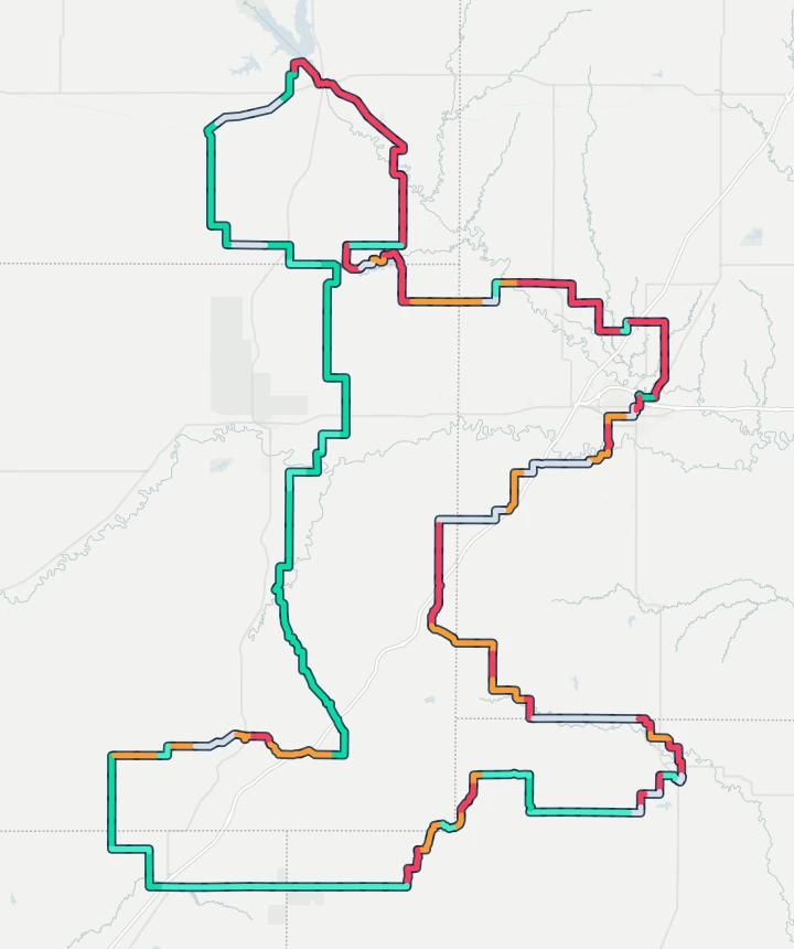 Start and finish · EmporiaMadisonCassodayMatfield GreenCouncil Grove123456Historic
- Strong tailwind
- Tailwind
- Side-on or light
- Headwind
- Strong headwind
Each stretch is coloured by how often the wind there was a headwind or a tailwind, at the hour a rider from the 06:30 start at about 22 km/h gets there, on the days around 5 June in 2015–2024 (Historic). The numbers are the six sections below.
Weather: contains modified Copernicus Climate Change Service information (ERA5). Route line: UNBOUND Gravel’s published 2026 200 Mile route (Ride with GPS, simplified). Map: OpenFreeMap, © OpenMapTiles, © OpenStreetMap contributors.
The loop runs south from Emporia to Madison, west past Texaco Hill to Cassoday, north through Matfield Green and Bazaar to Council Grove, then east through Americus back to Emporia. The way south from Emporia to Madison is red: the south wind was in your face on 4 to 5 days in 10. The run west towards Cassoday is mostly side-on, and the long way north from Matfield Green through Bazaar to Council Grove is green, with the wind behind on about 6 days in 10. The way home from Council Grove, south-east through Americus to Emporia, is red again, in your face on about 6 days in 10.
What is each section likely to feel like?
Each section with its usual race day, hour by hour, timed for a rider from the 06:30 start at about 22 km/h overall, checkpoint stops included.
1. Emporia to Madison
The first 3.3 miles out of downtown Emporia are under a neutral police escort, then the route heads south on gravel through Lyon and Greenwood counties to Checkpoint 1 in downtown Madison, at mile 42. In 2026 its cut-off was 11:30; at this pace you're there at about 09:30. It's about 19° at the start, and the south wind, about 9 km/h at dawn and building through the morning, is mostly in riders' faces: it added 15% or more effort on about half the days. This section was rated Good on 5 days in 10, Fair on 4 and Tough on 1.
- Wind
- 9 km/h from the southHeadwind adds 15% or more effort on 5 days in 10
- Effort
- about 13% more effortOn the middle day of the records
- Gusts
- 26 km/h41 km/h or more on 1 day in 10
- Air
- 19°Up to 23° by the end of the section
- Rain
- RarelyRain of 1 mm or more while riding it
The usual hour along the section on race day: air °C, wind and gusts km/h, and the share of hours with rain. An arrow shows the way the wind usually blows. The hours a 22 km/h rider is here are marked.
2. Madison to Texaco Hill
West from Madison into the open Flint Hills, to the first Water Oasis at Texaco Hill, mile 64. It's water only there, and no crews. The wind is about 12 km/h from the south by now, and more side-on as the route turns west: it added 15% or more effort on about 4 days in 10. It's about 25° by mid-morning, and this section was rated Good on 6 days in 10.
- Wind
- 12 km/h from the southHeadwind adds 15% or more effort on 4 days in 10
- Effort
- about 7% more effortOn the middle day of the records
- Gusts
- 31 km/h45 km/h or more on 1 day in 10
- Air
- 25°Up to 26° by the end of the section
- Rain
- RarelyRain of 1 mm or more while riding it
3. Texaco Hill and Cassoday to Matfield Green
Out to the far western edge of the loop near Cassoday, around mile 80, then north to Checkpoint 2 at the Matfield Green Old Homestead, mile 100.3. In 2026 the cut-off there was 16:30; at this pace you reach it at about 13:50, in the heat of the day. Mostly side-on or behind, about 13 km/h from the south. It's about 26 to 28°, 30° or more on about 3 days in 10, and this section was rated Good on 6 days in 10.
- Wind
- 13 km/h from the southHeadwind adds 15% or more effort on 2 days in 10
- Effort
- about levelOn the middle day of the records
- Gusts
- 35 km/h49 km/h or more on 1 day in 10
- Air
- 26°Up to 28° by the end of the section
- Rain
- 1 day in 10Rain of 1 mm or more while riding it
4. Matfield Green north to Council Grove
The longest stretch between checkpoints, almost 60 miles north through Chase and Morris counties, past Bazaar, to Checkpoint 3 at Council Grove High School, mile 160. In 2026 the cut-off was 23:30; at this pace you're there at about 18:10. With the stretch before it, the windiest part of the day, about 14 km/h from the south, but the wind is mostly behind: heading north, it gave back 10% or more of the effort on about 6 days in 10, and about 13% on the middle day. The heat is the catch: it's about 28 to 29° through the afternoon, and 30° or more on about 4 days in 10. This section was rated Good on 5 days in 10 and Fair on 4.
- Wind
- 14 km/h from the southTailwind gives 10% or more back on 6 days in 10
- Effort
- about 13% less effortOn the middle day of the records
- Gusts
- 35 km/h52 km/h or more on 1 day in 10
- Air
- 28°Up to 29° by the end of the section
- Rain
- 1 day in 10Rain of 1 mm or more while riding it
5. Council Grove to Americus
South-east from Council Grove towards the second Water Oasis at Americus, mile 189, water only. The evening comes on here: at this pace you pass Americus at about 20:20. Into the wind again as the route turns south-east: the wind, about 13 km/h from the south, added 15% or more effort on about 6 days in 10, and about 18% on the middle day. It's still about 28°, and this section was rated Tough on 2 days in 10, the most of any section.
- Wind
- 13 km/h from the southHeadwind adds 15% or more effort on 6 days in 10
- Effort
- about 18% more effortOn the middle day of the records
- Gusts
- 29 km/h49 km/h or more on 1 day in 10
- Air
- 28°Up to 28° by the end of the section
- Rain
- 1 day in 10Rain of 1 mm or more while riding it
6. Americus home to Emporia
The last 18 miles or so back into Emporia, to the finish on Commercial Street at about 21:40 at this pace. The finish line closes at 03:00 on Sunday morning. The headwind home: the evening breeze from the south-east, about 11 km/h, added 15% or more effort on about 6 days in 10. It's about 27° as you leave Americus, and this section was rated Good on only 4 days in 10.
- Wind
- 10 km/h from the south-eastHeadwind adds 15% or more effort on 6 days in 10
- Effort
- about 18% more effortOn the middle day of the records
- Gusts
- 21 km/h38 km/h or more on 1 day in 10
- Air
- 27°Up to 26° by the end of the section
- Rain
- RarelyRain of 1 mm or more while riding it
What should riders pack for race day?
Enough to get between checkpoints on your own: the course is unmarked, there are no shops between checkpoints, and outside support is allowed only at the three checkpoints. The organiser's 200 Mile athlete guide lists what you must carry, including a GPS or other navigation, a phone, and water for 50 miles (they recommend at least 2 litres), and suggests a red tail light. From the weather records:
- Summer kit, no layers. It was about 19° at the 06:30 start.
- Sunscreen and plenty to drink. It reaches about 29° through the middle of the day, and the two Water Oases are water only.
- A light rain jacket for the evening. It rained on about 3 days in 10.
- Save your legs for the last 80 km. From Council Grove the wind is usually in your face all the way home, so ride the tailwind north easy and find a group for the run through Americus.
Crews at Council Grove can expect about 28° by early evening.
When does the real forecast open?
Ten days before the race, in the Windline app: on 26 May 2027. Load the route with your own speed and start time, and Windline rates the day Good, Fair or Tough from the forecast, with the wind on every stretch at the hour you'll get there. From then on, trust the forecast over this preview.
How did we work this out?
The route was ridden again on every day from a week before to a week after 5 June, in each year from 2015 to 2024: 150 days. Each ride followed the organiser's published 2026 200 Mile route from the 06:30 age-group start at a steady 22 km/h, checkpoint stops included, on that day's hourly Copernicus ERA5 weather. Windline's engine, the same one the apps use, rated the ride and each section. The section names come from the organiser's checkpoints and the towns the route passes, in OpenStreetMap.
This is the 2026 course and the 2026 start time; the organiser hasn't published the 2027 routes or schedule yet. ERA5's grid cells are about 25 km across, and several cover this loop. Local showers and the shelter of a valley don't show. Historic weather, not a forecast.
Sources: UNBOUND Gravel's 200 page, with the 5 June 2027 date, and its home page; the 2026 schedule and the 2026 200 Mile athlete guide, with the start times, the checkpoints, water oases and cut-offs; the routes page and its 2026 200 Mile route on Ride with GPS, with the distance and climbing; ERA5 hourly time series (Hersbach et al., 2020). Contains modified Copernicus Climate Change Service information (2026). Neither the European Commission nor ECMWF is responsible for any use that may be made of the Copernicus information or data it contains.
Questions
When is Unbound Gravel 2027?
Saturday 5 June 2027, in Emporia, Kansas. The 200 is a single loop of 200 (+) miles on the gravel roads of the Flint Hills, 332.9 km on the organiser's 2026 route file. In 2026 the age-group field started at 06:30 on Commercial Street, after the elite men at 05:50 and the elite women at 06:05; the 2027 schedule isn't out yet.
Is Unbound Gravel windy?
Often breezy. The wind usually blows from the south, about 9 km/h at dawn and about 14 km/h from midday, gusting to about 32 km/h in the afternoon. In 10 years of records it was a headwind on the way south to Madison on about 4 to 5 days in 10, and on the way home from Council Grove through Americus on about 6 days in 10.
How hot is Unbound Gravel?
Warm, and hot on some days. A rider from the 06:30 start began at about 19° and, by the afternoon in the hills around Matfield Green and Council Grove, it was about 29°. It reached 30° or more during the ride on almost half the days, and 35° or more on fewer than 1 day in 10. The day's usual high was about 29°.
Does it rain on Unbound Gravel day?
On about 3 days in 10 around race day, 1 mm or more fell, most often in the late afternoon and evening. Rain while riding was less common, on about 3 days in 10. The organiser warns that in wet weather the gravel and dirt roads can become mud roads.
When will the Unbound Gravel forecast be available?
The real forecast opens 10 days before the race in the Windline app, on 26 May 2027. Until then, this preview is historic weather from 10 years of Copernicus ERA5 records, not a forecast.