Amashova 2027 weather: what race day will likely feel like
The short answer
Race day at the Amashova (Sunday 8 August 2027) is usually dry, with a cool start and a mild finish, about 12° at the 07:30 start in Pietermaritzburg and 21° at the finish in Durban. In 10 years of records the wind was light, usually from the west at about 9 km/h, behind riders for most of the first 60 km and more often in their faces on the run in to the beachfront.
The Amashova National Classic is on Sunday 8 August 2027: 106 km from Pietermaritzburg City Hall over Fox Hill, through Thornville, Camperdown and Cato Ridge, past the Comrades Wall of Honour and down Botha's Hill, then along the M13 and the N3 to a finish on Durban's beachfront. It drops from about 602 m to the sea, with 1,160 m of climbing on the way. Here's what race day has usually felt like, section by section, for a rider in the middle of the field.
What will the weather be like at the Amashova 2027?
Cool, dry and light on the wind, which mostly helps. In the records, a rider from the 07:30 start began at about 12° and finished at about 21°, before the day's high of about 23°. Windline's engine rated the whole ride Good on 9 days in 10, Fair on 1 and Tough on fewer than 1.
The wind is the story. It usually blew from the west at 9 km/h. The route runs east, from the Midlands down to the coast, so that light westerly is usually behind you for the first half, until the wind turns round to the east by late morning, closer to the coast.
| Section | Where | Wind | The wind’s effect | Air | Rated, days in 10 |
|---|---|---|---|---|---|
| 1 · 07:30km 0–24.5 | Pietermaritzburg over Fox Hill to Thornville | 8 km/hfrom the north-west | about 11% less effortHeadwind 4%, tailwind 32% of the way | 12° | |
| 2 · 08:25km 24.5–42 | Thornville to Camperdown and Cato Ridge | 8 km/hfrom the north-west | about 13% less effortHeadwind 4%, tailwind 42% of the way | 13° | |
| 3 · 09:05km 42–55 | Harrison Flats, Inchanga and Drummond | 7 km/hfrom the west | about 6% less effortHeadwind 6%, tailwind 29% of the way | 15° | |
| 4 · 09:34km 55–70 | Botha’s Hill, Hillcrest and Shongweni | 7 km/hfrom the west | about levelHeadwind 18%, tailwind 22% of the way | 19° | |
| 5 · 10:08km 70–94 | The M13 down Fields Hill, through Kloof and Westville | 9 km/hfrom the south-west | about 6% more effortHeadwind 19%, tailwind 13% of the way | 19° | |
| 6 · 11:02km 94–106 | The N3 to the beachfront | 12 km/hfrom the south-east | about 10% more effortHeadwind 29%, tailwind 12% of the way | 21° |
Where does the wind usually help, and where does it hurt?
It helps for most of the first 60 km, from Pietermaritzburg past Drummond, and hurts a little from about km 88 to the beachfront. On the hardest stretch, the wind added 40% or more effort on fewer than 1 day in 10, and about 11% on the middle day.
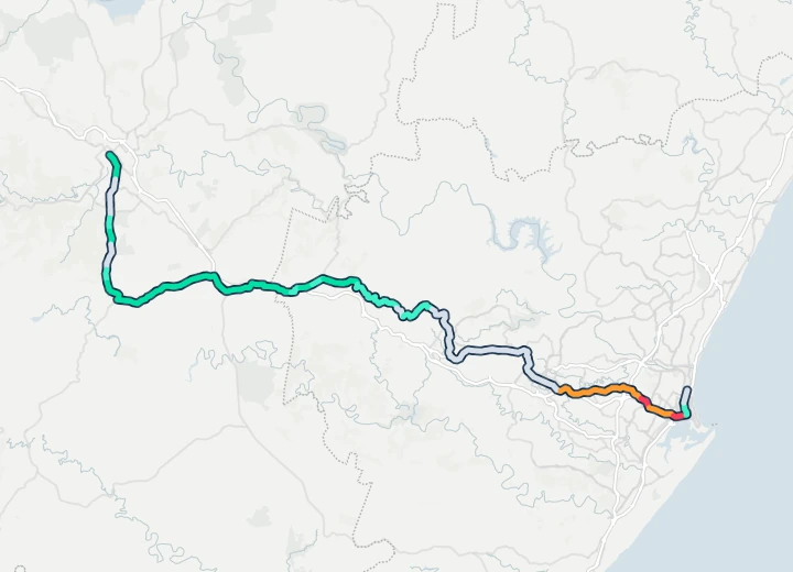 Start · Pietermaritzburg City HallCamperdownDrummondHillcrestWestvilleFinish · Durban beachfront123456Historic
- Strong tailwind
- Tailwind
- Side-on or light
- Headwind
- Strong headwind
Each stretch is coloured by how often the wind there was a headwind or a tailwind, at the hour a rider from the 07:30 start gets there, on the days around 8 August in 2015–2024 (Historic). The numbers are the six sections below.
Weather: contains modified Copernicus Climate Change Service information (ERA5). Route line: the Amashova’s published Google My Map (simplified). Map: OpenFreeMap, © OpenMapTiles, © OpenStreetMap contributors.
Green is the way from Pietermaritzburg through Camperdown, Cato Ridge and Inchanga to Drummond: the light westerly was behind you on up to 6 days in 10. Botha's Hill and the M13 sit in between, mostly side-on or light. Red is the run in from Westville to the beachfront, where the breeze off the sea was more often in your face.
What is each section likely to feel like?
Each section with its usual race morning, hour by hour, timed from the 07:30 start at about 26.5 km/h, the organiser's 4-hour split predictor.
1. Pietermaritzburg over Fox Hill to Thornville
From the Comrades gantry outside City Hall into Alexander Road and straight up Fox Hill on the R103, then left onto the R56 to Thornville and the first water point, past Gromor. It's about 12° at the start, with a light north-westerly of about 8 km/h that gave back 10% or more of the effort on about 6 days in 10. This section was rated Good on nearly every day in the records.
- Wind
- 8 km/h from the north-westTailwind gives 10% or more back on 6 days in 10
- Effort
- about 11% less effortOn the middle day of the records
- Gusts
- 21 km/h31 km/h or more on 1 day in 10
- Air
- 12°Up to 14° by the end of the section
- Rain
- RarelyRain of 1 mm or more while riding it
The usual hour along the section on race morning: air °C, wind and gusts km/h, and the share of hours with rain. An arrow shows the way the wind usually blows. The hours a 26.5 km/h rider is here are marked.
2. Thornville to Camperdown and Cato Ridge
The R603 to Camperdown, towards the Umlaas Road intersection and under the railway bridge, then the Camperdown link road and on to Cato Ridge, where the second water point is outside Eskom. Usually the fastest part of the day. The wind gave back 10% or more of the effort on about 6 days in 10, and was a headwind on almost none, taking about 13% off the effort on the middle day. It was rated Good on nearly every day.
- Wind
- 8 km/h from the north-westTailwind gives 10% or more back on 6 days in 10
- Effort
- about 13% less effortOn the middle day of the records
- Gusts
- 21 km/h31 km/h or more on 1 day in 10
- Air
- 13°Up to 15° by the end of the section
- Rain
- RarelyRain of 1 mm or more while riding it
3. Harrison Flats, Inchanga and Drummond
Along the R103 through Harrison Flats, over Inchanga and down to Drummond, past the Comrades Marathon Wall of Honour, where the third water point is. The first cut-off is at the Inchanga Caravan Park at 12:00. Still downwind, but more gently: about 7 km/h from the west, taking about 6% off the effort on the middle day. It's about 15° by now, and this section was rated Good on nearly every day.
- Wind
- 7 km/h from the westTailwind gives 10% or more back on 4 days in 10
- Effort
- about 6% less effortOn the middle day of the records
- Gusts
- 23 km/h32 km/h or more on 1 day in 10
- Air
- 15°Up to 18° by the end of the section
- Rain
- RarelyRain of 1 mm or more while riding it
4. Botha's Hill, Hillcrest and Shongweni
Past Kearsney College, then the fast descent down Botha's Hill into Hillcrest on Old Main Road, Hospital Road and Shongweni Road to the M13. The Botha's Hill Butchery cut-off is 13:00 and Shongweni Road, near the M13, is 14:00. The morning westerly fades here, to about 7 km/h, and it's about level on the effort on the middle day. It warms quickly, to about 19°, and this section was rated Good on 8 days in 10.
- Wind
- 7 km/h from the westTailwind gives 10% or more back on 2 days in 10
- Effort
- about levelOn the middle day of the records
- Gusts
- 22 km/h34 km/h or more on 1 day in 10
- Air
- 19°Up to 19° by the end of the section
- Rain
- RarelyRain of 1 mm or more while riding it
5. The M13 down Fields Hill, through Kloof and Westville
The westbound carriageway of the M13, ridden contraflow, down Fields Hill and through Kloof and Westville, with water points outside AutoTrak in Kloof and outside the Westville Mall, then down Jan Smuts Highway to the N3. The 45th Cutting cut-off, under the N3 bridge, is 14:30. It's about 20° by now, and the wind is turning, about 9 km/h with no settled direction, as the morning westerly gives way to an easterly off the sea. It added 15% or more effort on about 2 days in 10, and the section was rated Good on 7 days in 10.
- Wind
- 9 km/h from the south-westHeadwind adds 15% or more effort on 2 days in 10
- Effort
- about 6% more effortOn the middle day of the records
- Gusts
- 25 km/h41 km/h or more on 1 day in 10
- Air
- 19°Up to 21° by the end of the section
- Rain
- RarelyRain of 1 mm or more while riding it
6. The N3 to the beachfront
The outbound lanes of the N3 over the last hill under the Tollgate Bridge, down Monty Naicker Road and Walnut Road to the finish on Masabalala Yengwa Avenue, under the pedestrian bridge between the Mustering Fields and People's Park. The likeliest place to lose time to the weather. It's about 21° at the finish, and the breeze off the sea, about 12 km/h from the south-east, added 15% or more effort on about 3 days in 10. This section was rated Good on 6 days in 10 and Fair on 4, the lowest of the day.
- Wind
- 12 km/h from the south-eastHeadwind adds 15% or more effort on 3 days in 10
- Effort
- about 10% more effortOn the middle day of the records
- Gusts
- 26 km/h43 km/h or more on 1 day in 10
- Air
- 21°Up to 21° by the end of the section
- Rain
- RarelyRain of 1 mm or more while riding it
What should riders pack for race day?
Layers for a cool start, summer kit underneath, and rarely rain gear. The organiser's 106 km page, route description and cut-off times have the details, and the final instructions will carry the 2027 batch times. From the weather records:
- Arm warmers and a gilet you can stow. It was about 12° at the start.
- Pockets for the layers on the way down. It reaches about 21° by the finish.
- A rain jacket only if the forecast says so. Rain fell while riding on fewer than 1 day in 10, and 1 mm or more on about 2 days in 10 around race day.
- Brakes and focus for the descents. Botha's Hill, Fields Hill and Jan Smuts Highway all come in the second half.
Supporters on the beachfront can expect about 21° by late morning.
When does the real forecast open?
Ten days before the race, in the Windline app: on 29 July. Load the route with your own speed and batch, and Windline rates the day Good, Fair or Tough from the forecast, with the wind on every stretch at the hour you'll get there. From then on, trust the forecast over this preview.
How did we work this out?
The route was ridden again on every day from a week before to a week after 8 August, in each year from 2015 to 2024: 150 days. Each ride followed the organiser's published route line from the 07:30 start at a steady 26.5 km/h, the speed of the organiser's 4-hour split predictor, on that day's hourly Copernicus ERA5 weather. Windline's engine, the same one the apps use, rated the ride and each section. The sections follow the organiser's route description and split predictor.
The line is the organiser's map of the 2023 route, the latest it has published; the 2027 route description follows the same roads. It measures 101.4 km against the official 106 km, so the timing is scaled to the official distance. Batch times come out in race week, so a mid-field batch starts a little after 07:30. ERA5's grid cells are about 25 km across, so the valleys, the shelter of the cuttings and the sea breeze on the coast don't fully show. Where ERA5's hourly temperature steps every three hours (its weather stations there report every three hours), it's read at 00, 03, … 21 UTC and joined in straight lines, as Windline's route pages read it. Historic weather, not a forecast.
Sources: the Amashova's 106 km page (the date and the 07:30 start), its FAQ (the start times and venues), route description, route profile (106 km, 1,160 m of climbing), route map (the route line), cut-off times, approach to the 106 km start (the batches) and final instructions (the split predictors); ERA5 hourly time series (Hersbach et al., 2020). Contains modified Copernicus Climate Change Service information (2026). Neither the European Commission nor ECMWF is responsible for any use that may be made of the Copernicus information or data it contains.
Questions
When is the Amashova 2027?
Sunday 8 August 2027. The 106 km National Classic starts at 07:30 outside Pietermaritzburg City Hall, under the Comrades gantry, and finishes on Masabalala Yengwa Avenue on Durban's beachfront. Riders start in seeded batches, and the batch times are sent to entrants in race week. The 70 km starts in Camperdown at 06:15 and the 40 km fun ride in Shongweni at 06:30.
Is the Amashova windy?
Not very. The morning wind is usually light, about 7 to 9 km/h from the west, and it swings round to the east by late morning, as riders near the coast. In 10 years of records the first 50 km, past Cato Ridge, had the wind behind on about 3 to 6 days in 10, and the last stretch, from Westville along the N3, was more often a headwind, on about 2 to 3 days in 10.
How cold or hot is the Amashova?
Cool at the start inland, mild on the coast, and rarely hot. A rider from the 07:30 start began at about 12° and finished at about 21°. The day's high in Durban was usually about 23°.
Does it rain on Amashova day?
Rarely. 1 mm or more fell on about 2 days in 10 around race day, and the chance of rain in any morning hour was about 1 in 20. Rain while riding was rare, on fewer than 1 day in 10.
When will the Amashova forecast be available?
The real forecast opens 10 days before the race in the Windline app, on 29 July. Until then, this preview is historic weather from 10 years of Copernicus ERA5 records, not a forecast.