Cape Town Cycle Tour 2027 weather: what race day will likely feel like
The short answer
Race day at the Cape Town Cycle Tour (Sunday 14 March 2027) is usually mild, mostly dry and windy, about 18° at a 07:48 start and 20° by the finish. In 10 years of records the wind was usually from the south-east at about 22 km/h, in riders' faces on the way south to the Cape Point gate and behind them on the way back up the Atlantic side.
The Cape Town Cycle Tour is on Sunday 14 March 2027: 109 km from the Grand Parade in Cape Town over Wynberg Hill, down the False Bay coast to Simon's Town and the Cape Point gate, and back up the Atlantic side over Chapman's Peak and Suikerbossie to a finish in Green Point. Here's what race day has usually felt like, section by section, for a rider in the middle of the field.
What will the weather be like at the Cape Town Cycle Tour 2027?
Mild, mostly dry, and windy. In the records, a rider in group 5C, starting at 07:48, began at about 18° and finished at about 20°, close to the day's high of about 21° in the city. Windline's engine rated the whole ride Good on 2 days in 10, Fair on 4 and Tough on 4.
The wind is the story. It usually blew from the south-east at 22 km/h. The route goes south down the False Bay side and back north up the Atlantic side, so it was usually a headwind on the first half, down to the Cape Point gate, and a tailwind on the second, all the way home.
| Section | Where | Wind | The wind’s effect | Air | Rated, days in 10 |
|---|---|---|---|---|---|
| 1 · 07:48km 0–14 | The Grand Parade to Wynberg Hill | 17 km/hfrom the south-east | about 46% more effortHeadwind 56%, tailwind 22% of the way | 18° | |
| 2 · 08:24km 14–39 | Wynberg Hill to Simon’s Town | 20 km/hfrom the south-east | about 47% more effortHeadwind 49%, tailwind 21% of the way | 18° | |
| 3 · 09:29km 39–58 | Smitswinkel and the Cape Point gate | 23 km/hfrom the south-east | about 24% more effortHeadwind 43%, tailwind 44% of the way | 18° | |
| 4 · 10:19km 58–78 | Scarborough and Misty Cliffs to Noordhoek | 23 km/hfrom the south-east | about 17% less effortHeadwind 20%, tailwind 50% of the way | 18° | |
| 5 · 11:11km 78–88 | Chapman’s Peak to Hout Bay | 24 km/hfrom the south | about 27% less effortHeadwind 20%, tailwind 56% of the way | 17° | |
| 6 · 11:37km 88–109 | Suikerbossie, Camps Bay and Sea Point to the finish | 22 km/hfrom the south | about 26% less effortHeadwind 15%, tailwind 57% of the way | 17° |
Where does the wind usually help, and where does it hurt?
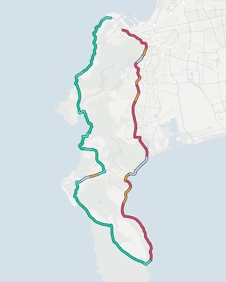
It hurts for the first 47 km or so, from the Grand Parade to the Cape Point gate, and helps from there to the finish, apart from a short stretch side-on past Masiphumelele. On the hardest stretch, from about km 14, after Wynberg Hill, to km 47, the wind added 40% or more effort on about 8 days in 10, and about 71% on the middle day.
 Start · Grand ParadeMuizenbergSimon’s TownScarboroughHout BayFinish · Green Point123456Historic
- Strong tailwind
- Tailwind
- Side-on or light
- Headwind
- Strong headwind
Each stretch is coloured by how often the wind there was a headwind or a tailwind, at the hour a group 5C rider gets there, on the days around 14 March in 2015–2024 (Historic). The numbers are the six sections below.
Weather: contains modified Copernicus Climate Change Service information (ERA5). Route line: “Cape Town Cycle Tour 2025 109km” on Ride with GPS (simplified). Map: OpenFreeMap, © OpenMapTiles, © OpenStreetMap contributors.
The organiser's own route description warns of it: the flat run back from Scarborough towards Fish Hoek and Noordhoek goes "straight into the South Easter" on the days it blows. In the records, though, it was usually behind riders there, not in their faces. Red is the False Bay side, from the Grand Parade over Wynberg Hill to Simon's Town and on to the Cape Point gate: the south-easter was in your face on 6 to 7 days in 10. Green is everything after the turn, through Scarborough, over Chapman's Peak and Suikerbossie to Green Point, where it was usually behind you. The one stretch side-on to it is the road past Masiphumelele towards Noordhoek, the very stretch the organiser warns of; ERA5's 25 km cells can't see the wind funnelling between the mountains there, so trust the organiser on a windy day.
What is each section likely to feel like?
Each section with its usual race morning, hour by hour, timed for group 5C at about 23 km/h.
1. The Grand Parade to Wynberg Hill
Past the Castle and straight into the first climb of the day, Nelson Mandela Boulevard, then through Hospital Bend, past UCT and Newlands Forest to Edinburgh Drive, the steep ramp the organiser calls Wynberg Hill. The first refreshment station is at Constantia, at about km 14. It's about 18° at the start, with the south-easter at about 17 km/h in riders' faces: it added 15% or more effort on about 7 days in 10, and about 46% on the middle day. This section was rated Good on only 3 days in 10, and Tough on 5.
- Wind
- 17 km/h from the south-eastHeadwind adds 15% or more effort on 7 days in 10
- Effort
- about 46% more effortOn the middle day of the records
- Gusts
- 29 km/h43 km/h or more on 1 day in 10
- Air
- 18°Up to 18° by the end of the section
- Rain
- RarelyRain of 1 mm or more while riding it
The usual hour along the section on race morning: air °C, wind and gusts km/h, and the share of hours with rain. An arrow shows the way the wind usually blows. The hours a 23 km/h rider is here are marked.
2. Wynberg Hill to Simon's Town
The fast 25-odd kilometres down to the False Bay coast and along it through St James to Simon's Town, with refreshment stations at Tokai and St James station. The first cut-off is at the end of the M3 at 10:15. Fast on the map, but rarely in the records. The south-easter, about 20 km/h by now, added 15% or more effort on about 7 days in 10 and gave some back on about 2, adding about 47% on the middle day. It was rated Tough on 6 days in 10, the most of any section.
- Wind
- 20 km/h from the south-eastHeadwind adds 15% or more effort on 7 days in 10
- Effort
- about 47% more effortOn the middle day of the records
- Gusts
- 33 km/h52 km/h or more on 1 day in 10
- Air
- 18°Up to 19° by the end of the section
- Rain
- RarelyRain of 1 mm or more while riding it
3. Smitswinkel and the Cape Point gate
The long drag up past Smitswinkel to the entrance of the Cape Point Nature Reserve, almost halfway, with refreshment stations at Partridge Point, Klaas Jagersberg and Perdekloof. The Perdekloof cut-off is 13:00. Still into the wind until the turn, at about 23 km/h from the south-east, adding 15% or more effort on about 7 days in 10 and about 24% on the middle day. It was rated Fair on 5 days in 10 and Tough on 2.
- Wind
- 23 km/h from the south-eastHeadwind adds 15% or more effort on 7 days in 10
- Effort
- about 24% more effortOn the middle day of the records
- Gusts
- 32 km/h52 km/h or more on 1 day in 10
- Air
- 18°Up to 18° by the end of the section
- Rain
- RarelyRain of 1 mm or more while riding it
4. Scarborough and Misty Cliffs to Noordhoek
The traverse through Scarborough and Misty Cliffs, with the best view of the ocean all day, then the flat run past Masiphumelele towards Noordhoek, which the organiser says goes into the South Easter when it blows. The Noordhoek cut-off is 14:00. In the records the south-easter was usually behind riders here, not in their faces: a headwind added 15% or more effort on only about 2 days in 10, and on the middle day the wind took about 17% off the effort. The danger is the gusts, about 37 km/h, and 59 km/h or more on 1 day in 10. Crosswind gusts made this section Tough on about 3 days in 10, and it was rated Good on 5.
- Wind
- 23 km/h from the south-eastTailwind gives 10% or more back on 7 days in 10
- Effort
- about 17% less effortOn the middle day of the records
- Gusts
- 37 km/h59 km/h or more on 1 day in 10
- Air
- 18°Up to 20° by the end of the section
- Rain
- RarelyRain of 1 mm or more while riding it
5. Chapman's Peak to Hout Bay
Little Chappies, short and steep, then the longer, flatter main climb of Chapman's Peak and the fast descent into Hout Bay. The Hout Bay cut-off, at the Main Road and Princess Road circle, is 15:00. It's about 17° by now, and the wind, about 24 km/h from the south, usually pushes riders up Chapman's Peak: it gave back 10% or more of the effort on about 7 days in 10, and about 27% on the middle day. This section was rated Good on 6 days in 10.
- Wind
- 24 km/h from the southTailwind gives 10% or more back on 7 days in 10
- Effort
- about 27% less effortOn the middle day of the records
- Gusts
- 31 km/h50 km/h or more on 1 day in 10
- Air
- 17°Up to 17° by the end of the section
- Rain
- RarelyRain of 1 mm or more while riding it
6. Suikerbossie, Camps Bay and Sea Point to the finish
A kilometre and a half up Suikerbossie, then about fifteen downhill and flat kilometres through Bakoven, Camps Bay, Clifton and Sea Point to the finish in Green Point. The Bakoven cut-off is 16:00 and the finish closes at 17:00. It's about 20° at the finish, and the wind, about 22 km/h from the south, was usually behind riders all the way to Green Point, giving back 10% or more of the effort on about 7 days in 10. This section was rated Good on 6 days in 10, and Tough on only 1.
- Wind
- 22 km/h from the southTailwind gives 10% or more back on 7 days in 10
- Effort
- about 26% less effortOn the middle day of the records
- Gusts
- 34 km/h52 km/h or more on 1 day in 10
- Air
- 17°Up to 20° by the end of the section
- Rain
- RarelyRain of 1 mm or more while riding it
What should riders pack for race day?
Light summer kit, a gilet for the start, and a plan for the wind. The organiser's 109 km page has the route map, the start and finish details, the refreshment stations and the cut-offs, and it notes that the Grand Parade is exposed, so a light gilet helps at the start. From the weather records:
- Summer kit and a light gilet. It was about 18° at the start.
- Sunscreen and bottles. It reaches about 20° by the finish, with 12 refreshment stations on the course.
- Rain gear only if the forecast calls for it. 1 mm or more fell on about 2 days in 10 around race day, and rain while riding on about 1 day in 20.
- Legs for the Atlantic side. Chapman's Peak and Suikerbossie come after 78 km, and the run to Noordhoek usually has the wind behind, though its gusts can be strong.
Supporters in Green Point can expect about 20° by late morning.
When does the real forecast open?
Ten days before the race, in the Windline app: on 4 March. Load the route with your own speed and start group, and Windline rates the day Good, Fair or Tough from the forecast, with the wind on every stretch at the hour you'll get there. From then on, trust the forecast over this preview.
How did we work this out?
The route was ridden again on every day from a week before to a week after 14 March, in each year from 2015 to 2024: 150 days. Each ride followed a public GPX of the official 109 km course from group 5C's 07:48 start (its 2026 start time) at a steady 23 km/h, on that day's hourly Copernicus ERA5 weather. Windline's engine, the same one the apps use, rated the ride and each section. The sections follow the organiser's route description and refreshment stations.
It's the 2025 course, still the organiser's published route; the organiser hasn't published 2027 changes or start times yet. ERA5's grid cells are about 25 km across, so the wind funnelling round the mountains, the shelter of the cliffs and the sea breeze don't fully show. Where ERA5's hourly temperature steps every three hours (its weather stations there report every three hours), it's read at 00, 03, … 21 UTC and joined in straight lines, as Windline's route pages read it. Historic weather, not a forecast.
Sources: the Cape Town Cycle Tour's 109 km page, with the date, the route description, the 2026 start groups and times, the cut-offs and the Strava route, its 109 km route map, with the refreshment stations and the total elevation of 1,200 m, and its home page; the route line, "Cape Town Cycle Tour 2025 109km" on Ride with GPS; ERA5 hourly time series (Hersbach et al., 2020). Contains modified Copernicus Climate Change Service information (2026). Neither the European Commission nor ECMWF is responsible for any use that may be made of the Copernicus information or data it contains.
Questions
When is the Cape Town Cycle Tour 2027?
Sunday 14 March 2027. The 109 km ride starts at the Grand Parade in Cape Town, goes around the Cape Peninsula over Chapman's Peak and Suikerbossie, and finishes in Green Point. In 2026 the start groups went from 06:15 to 10:15; the organiser hasn't published the 2027 start times yet.
Is the Cape Town Cycle Tour windy?
Usually, yes. In the records the wind blew from the south-east at about 22 km/h right through the morning, gusting to about 31 km/h. In 10 years of records the False Bay side, from the city to the Cape Point gate, was a headwind on about 6 to 7 days in 10, and the Atlantic side, from Scarborough over Chapman's Peak to Green Point, had the wind behind on about 6 to 7 days in 10.
How hot is the Cape Town Cycle Tour?
Not very. The sea keeps it mild. A group 5C rider started at about 18° and finished at about 20°, and none of the 150 days in the records reached 30° during the ride; the warmest reached 26°. The day's high was usually about 19 to 21°.
Does it rain on Cape Town Cycle Tour day?
Not often. 1 mm or more fell on about 2 days in 10 around race day, and the chance of rain in any morning hour was about 1 in 15. Rain while riding was rare, on about 1 day in 20.
When will the Cape Town Cycle Tour forecast be available?
The real forecast opens 10 days before the race in the Windline app, on 4 March. Until then, this preview is historic weather from 10 years of Copernicus ERA5 records, not a forecast.